
(This story originally appeared in the October-November 2022 print edition of the South Baltimore Peninsula Post.)
EDITOR’S NOTE – In the 1950s, when plans for a nationwide interstate highway system were born, cities across the country began to grapple with how to make room for expressways snaking through dense urban landscapes. Baltimore was no exception, and the ensuing “road wars” over those plans were fought into the 1970s. Many Baltimore communities were in the crosshairs, including much of the South Baltimore peninsula.
In the new book Stop the Road: Stories from the Trenches of Baltimore’s Road Wars (Boyle & Dalton) released in September, former Baltimore city planner E. Evans Paull chronicles the improbable victory of the powerless and the outsiders over the powerful and the insiders, with the result that Baltimore’s historic waterfront communities of Federal Hill, Fell’s Point, and Canton were saved from the wrecking ball. But that win was tempered by the disastrous losses of the “Highway to Nowhere” and destruction of Black neighborhoods.
Baltimore developer and urban strategist C. William Struever commented in a 2004 interview that, “If you think about the things that have really changed the face of Baltimore as we know it today, to me there is nothing more important than the road wars.”
Stop the Road dives into the controversies and behind-the-scenes power plays at the heart of the decades-long struggle to build Baltimore’s expressways and interstates. Paull interviewed 55 key players to tackle major questions, including: Why were highway engineers hell-bent on a plan that would have destroyed the waterfront? Was Baltimore guilty of using highways for “Negro removal”? Who were these unsung heroes, the outsiders that saved Baltimore from its own leadership?
Below are excerpts adapted from the book that focus on the major battles fought here in SoBo. Stop the Road is available through Amazon and Barnes & Noble.
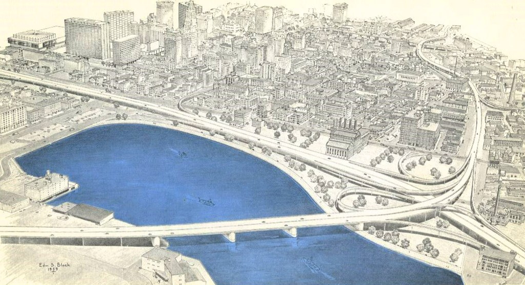
In 1961, Baltimore’s team of consulting engineers released the highway scheme that called for an eight-lane East-West Expressway to cross South Baltimore at Montgomery Street; swipe through Federal Hill (taking a large chunk out of Federal Hill Park); cross the Inner Harbor with a fourteen-lane, low-level bridge; occupy Harbor East with a colossal, six-level interchange; rip through the heart of Fell’s Point at Broadway and Thames; and then follow the Canton waterfront all the way to the Canton industrial area. From our modern-day point of view, it is hard to imagine anything—save, perhaps, a nuclear power plant—that would have had a more deadening effect on future urban vitality.
There is also a parallel story that is equally compelling as a civic tragedy. The tragic side of the highway fight takes us to the African American communities of Sharp Leadenhall and Rosemont; the former a textbook example of the detrimental impact of the all-too-prevalent practice of using highways for slum clearance, the latter revealing Baltimore’s low regard for a stable, middle-class African American neighborhood.
Eventually, Baltimore’s highway planners acceded to those opposed to this plan and accepted one through-highway (I-95, moved away from downtown and neighborhoods to an industrial corridor) and two spurs, I-83 and I-395, truncated highways that improved downtown access but avoided the more destructive aspects of a highway system that looked great on a map but would have ripped the heart out of affected communities.
Destruction in Sharp Leadenhall
At the time of the Road Wars, Sharp Leadenhall was a lower-income, African American neighborhood with rental properties predominating. Its roots as a proud community of African American Freedmen were ripped apart in the late 1960s, another community destroyed by acquisitions for highway plans that were later changed. Two highway plans and one urban renewal plan left a decimated community of only five hundred holdouts—three thousand people had been relocated.
Conventional wisdom in city planning in the mid ’60s still favored slum clearance via both urban renewal and highway construction. Sharp Leadenhall was in the crosshairs for both in the 1962 plan and a modified 1967 plan. The 1962 plan swiped through the neighborhood east to west, wiping out four blocks and bisecting the community into northern and southern sections.
The modified route buried Sharp Leadenhall at the intersection of two superhighways: I-95 (running north to south and laying waste to eight mixed residential and commercial blocks) and the I-70 southwest connector (running east to west and displacing mostly commercial properties at the north end of Sharp Leadenhall. The modified plan was adopted by condemnation ordinance in November 1967.
But one year later, in December 1968, Mayor D’Alesandro ditched the plan to have I-95 cross the harbor at Federal Hill to one that crossed at Fort McHenry. The new alignment was linked to downtown via the I-395 spur. I-395 used the same north-south corridor through Sharp Leadenhall, but at six lanes instead of eight, the right-of-way narrowed by one block, staying west of Sharp Street rather than Leadenhall Street. That narrowing would have freed up four blocks from the Sharp Leadenhall condemnation area; however, because Locust Point put up a huge fight against the Fort McHenry route, Sharp Leadenhall stayed in limbo from 1968 to 1973, except that it was worse than limbo because acquisitions continued even though the city’s plan had changed.
Protecting Federal Hill
Although concepts for an alternate route across the harbor at Fort McHenry instead of Federal Hill were percolating behind the scenes in the late 1960s, the expressway through the Inner Harbor at Federal Hill was the official plan for 12 years (1961 to 1973).
Up until about 1967, anti-highway activists were essentially folks trying to protect their neighborhoods along with a smattering of historic preservation and civil rights advocates. But in the late ’60s, young people, both white and Black, began questioning pretty much everything the establishment stood for.
The spirit of 1960s activism played a major part in the expressway battle. Idealists and activists brought new energy and zeal to the fight, not to protect their own neighborhoods but because their involvement fit into their sense of purpose and worldview—that working class and minority neighborhoods were being victimized because they were powerless.
Highway opposition began to take on new forms. Organizations were created for the sole purpose of altering or stopping expressways. Fell’s Pointers and historic preservation advocates pulled together and formed the Society for the Preservation of Federal Hill and Fell’s Point (Preservation Society) in February 1967.
At the time of the Road Wars, Federal Hill was a mixed-income and mixed-race community with industrial uses mixed in, especially along the waterfront. The community and the Preservation Society were relatively minor players in this battle – larger forces such as the Greater Baltimore Committee and city development agencies were at work pressing against the Federal Hill crossing – except for one critical matter: placing Federal Hill on the National Register of Historic Places.
Fell’s Point activists Bob Eney and Jack Gleason repeated their Fell’s Point spadework for Federal Hill and succeeded in gaining National Register status in April 1970. The Federal Hill Historic District was also incorporated into the Fell’s Point lawsuit in August 1973.
Locust Point Fights Back
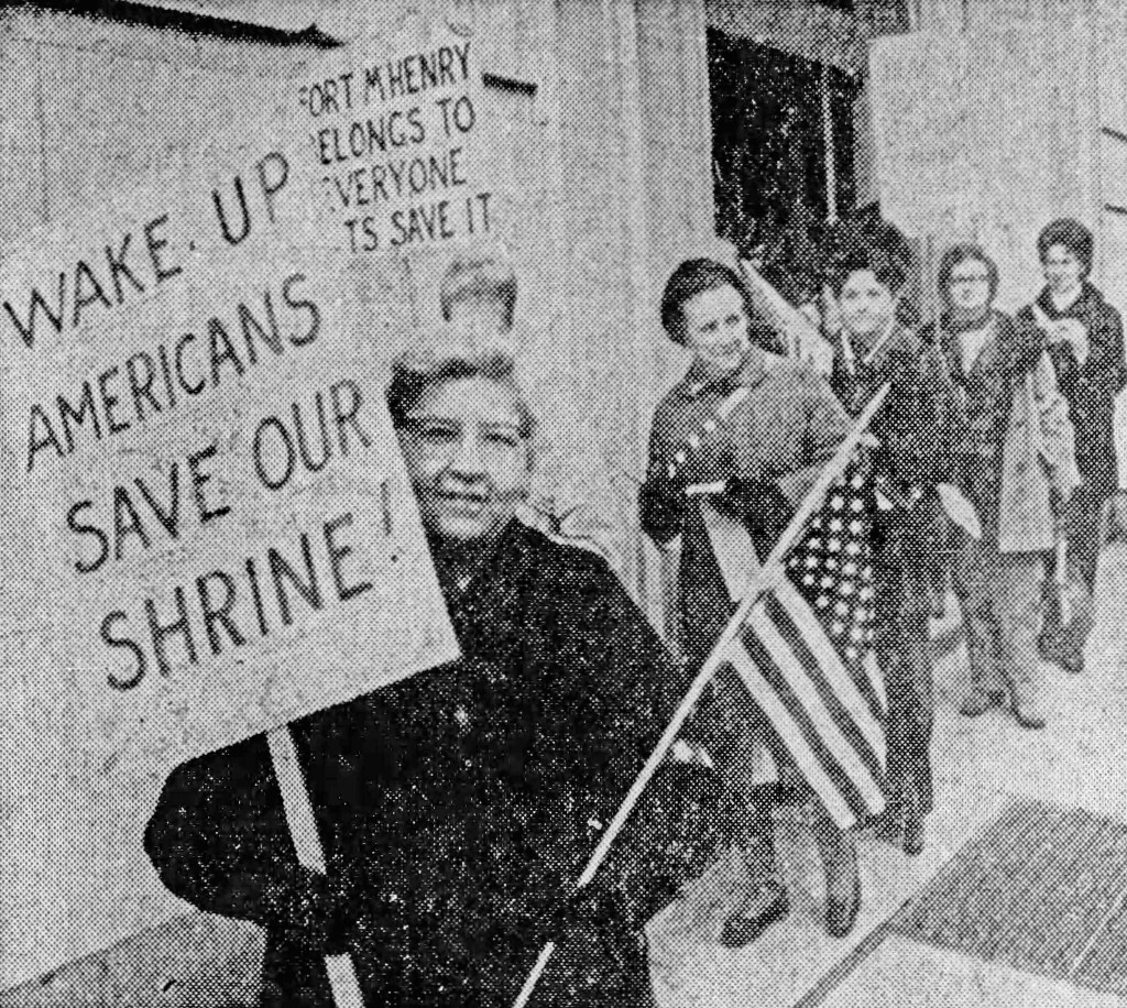
The Fort McHenry harbor crossing had one enormous problem: the proposed 180-foot-high bridge was seen as a desecration of the Fort McHenry monument. Intense community opposition supplemented by well-organized veterans’ organizations achieved a quick result. In April 1971 the Maryland General Assembly passed a resolution draped in patriotism: “a call to…all veterans groups and all other patriotic Marylanders and Americans to aid and support the protection of our national heritage in Fort McHenry.” It specifically requested that the State Roads Commission “fix an alternate route for an extension of I-95 so that Fort McHenry will not be jeopardized.”

Shirley and Victor Doda are generally credited as the Locust Point masterminds who forced the road establishment to build a tunnel instead of a bridge at Fort McHenry. It was seen as a compromise at the time, but please imagine a Chesapeake Bay Bridge-like structure looming over Fort McHenry. This was no small victory.
Shirley and Victor Doda were admired by both friend and foe. Shirley, sometimes called the First Lady of Locust Point, had a knack for attention-getting antics. One protest outside City Hall featured a woman dressed up as a gorilla who handed out bananas inscribed with a warning: “Don’t Monkey with Locust Point.” Shirley led a procession of neighborhood folks (each with a red, white, and blue hat) to Monday night council meetings, where she would sit directly behind Schaefer.
Technical studies for the Fort McHenry tunnel were completed in April 1974. There were three options for bypassing the Fort, but Mayor Schaefer favored the most complete (and expensive) solution which moved the tunnel to the east and south. The visual impact of the highway was virtually eliminated. These options finally went before the Locust Point community in December 1974. Victor Doda said the community was still concerned about the impact of construction vibration and air pollution, but the condemnation ordinance passed in a 12-5 vote on January 23, 1975.

A driving forced behind “STOP THE ROAD” Was my mother Dolores B. Canoles. Did you try to contact my brother Thomas B. Canoles Jr. who could give detail to this subject. Just wondering. I was about 7 and remember my mother lying down in front of trucks to get her point across. Barbra Mikulski was always over our house drinking coffee all the time.
LikeLike